Long-Range Flying and Extended FPV Drone Operations

After years of pushing the boundaries of what's possible with FPV drones, I've learned that long-range flying represents both the ultimate freedom and the ultimate responsibility in our hobby. This comprehensive guide distills my experience from hundreds of long-range missions—from my first nerve-wracking 1km flight to multi-kilometer mountain crossings and beyond—covering everything you need to know about safely and legally extending your flight envelope.
Introduction to Long-Range Flying
Long-range flying involves operating drones beyond visual line of sight (BVLOS) or at distances significantly greater than typical FPV flights. While standard FPV flights might keep the drone within 500 meters, long-range flights can extend to several kilometers or even tens of kilometers.
This type of flying offers unique experiences and capabilities:
- Exploration: Access to remote landscapes and perspectives
- Adventure: The thrill of pushing boundaries and discovering new areas
- Cinematic Opportunities: Capturing footage otherwise impossible to obtain
- Technical Challenge: Mastering the systems and skills required for safe extended operations
However, long-range flying comes with significant responsibilities:
- Legal Compliance: Understanding and following regulations that often explicitly restrict BVLOS operations
- Safety Management: Implementing robust systems to prevent flyaways and accidents
- Technical Expertise: Mastering more complex systems than typical FPV requires
- Environmental Awareness: Respecting wildlife and natural areas during extended flights
Before my first long-range flight, I spent months researching, testing equipment, and practicing skills. This preparation wasn't excessive—it was essential. Long-range flying leaves little room for error, as problems that would be minor close to home can become catastrophic when your aircraft is kilometers away.
Legal Considerations for Long-Range Flying
The legal landscape for long-range flying varies dramatically by country and region, but almost universally includes restrictions on beyond visual line of sight (BVLOS) operations.
Understanding BVLOS Regulations
Most drone regulations worldwide include some version of this fundamental rule: you must maintain visual line of sight with your aircraft at all times. This creates an inherent tension with long-range FPV flying, where the pilot's primary view is through the camera.
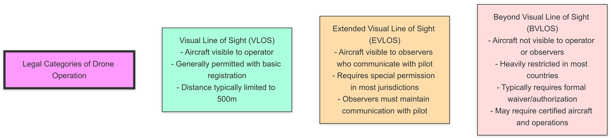
Legal Approaches to Long-Range Flying
There are several approaches to conducting long-range operations within legal frameworks:
- Obtain BVLOS Authorization: Some jurisdictions offer pathways to authorized BVLOS operations
- Requires formal application process
- May require operator certification
- Often limited to commercial operations
- Typically involves extensive safety documentation
- EVLOS Operations: Using visual observers to maintain technical compliance
- Observers must maintain visual contact with the aircraft
- Reliable communication between pilot and observers is essential
- May require prior notification or permission
- Observers must understand their responsibilities
- Fly in Unrestricted Areas: Some countries have remote areas with reduced restrictions
- Still requires adherence to altitude and other limitations
- May require prior notification to authorities
- Often requires significant travel to reach suitable locations
- Special Events/Locations: Sanctioned events or designated areas
- Drone racing leagues sometimes secure BVLOS permissions for events
- Some countries have established drone corridors or test areas
- Usually temporary and limited in scope
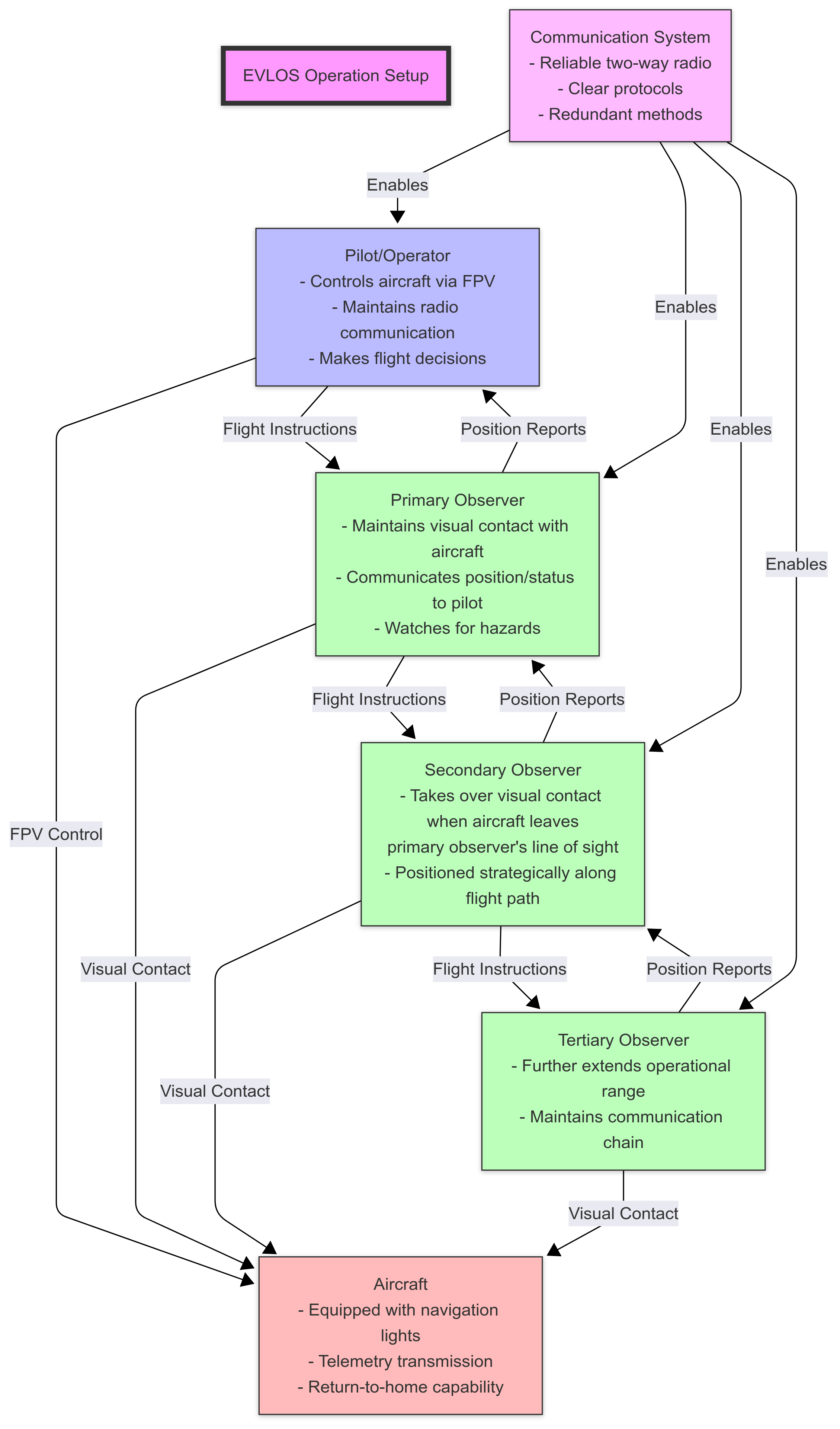
I've found that the EVLOS approach, when properly implemented with reliable observers and communication, offers the most practical path for responsible enthusiasts in many regions. However, this requires careful planning and absolute honesty about whether your setup truly maintains visual line of sight through observers.
Country-Specific Regulations
Regulations vary significantly by country. Here's an overview of approaches in major regions:
| Country/Region | Regulatory Body | BVLOS Possibility | EVLOS Approach | Special Considerations | Required Documentation |
|---|---|---|---|---|---|
| European Union | EASA | Possible in Specific Category with SORA process | May require authorization | Three-tiered system: Open, Specific, Certified categories | Registration, operator ID, risk assessment for Specific Category |
| United States | FAA | Extremely limited, waivers rarely granted to individuals | Not formally recognized | Remote ID now required | Registration, TRUST certificate for recreational, Part 107 for commercial |
| United Kingdom | CAA | Possible with Operational Safety Case (OSC) | Relatively straightforward process | Similar to pre-Brexit EU rules | Operator ID, flyer ID, registration for drones >250g |
| Australia | CASA | Possible for ReOC holders (commercial) | Permitted with proper protocols | More flexible in remote areas | Registration, operator accreditation or RePL |
| Switzerland | FOCA | Requires special authorization | May be permitted with prior approval | Special considerations for mountain flying | Registration, operator ID, special authorization for BVLOS |
| Canada | Transport Canada | Limited to SFOC holders | Possible with proper protocols | Advanced operations category | Basic or advanced pilot certificate, registration |
| New Zealand | CAA | Possible with Part 102 certification | Recognized with proper protocols | Relatively progressive approach | Part 101 compliance or Part 102 certification |
European Union (EASA Regulations)
The EU operates under a unified regulatory framework:
- Open Category: Generally prohibits BVLOS operations
- Specific Category: Allows BVLOS with risk assessment (SORA process)
- Certified Category: For complex BVLOS operations (primarily commercial)
For hobbyists, the Specific Category offers a potential pathway through the SORA (Specific Operations Risk Assessment) process, though this is complex and typically used by commercial operators.
United States (FAA Regulations)
The FAA maintains strict BVLOS restrictions:
- Part 107 (Commercial) and Recreational rules both prohibit BVLOS
- Waivers are available but rarely granted to individuals
- Remote ID requirements now make aircraft trackable at distance
- Recreational flights must remain within visual line of sight
United Kingdom
Post-Brexit, the UK maintains regulations similar to EASA:
- Standard permissions require VLOS operations
- Operational Safety Case (OSC) can enable BVLOS
- Relatively straightforward process for EVLOS with observers
Australia (CASA Regulations)
Australia offers some flexibility:
- Standard operations require VLOS
- ReOC holders (commercial) can apply for BVLOS approvals
- EVLOS operations possible with observers
- Remote areas have seen more permissive enforcement
Switzerland
Switzerland has specific considerations:
- FOCA regulations generally align with EASA framework
- BVLOS operations require special authorization
- Mountain flying has additional considerations due to terrain
- EVLOS operations with observers may be permitted with prior authorization
For more detailed information on country-specific regulations, see these comprehensive guides:
Practical Legal Approach for Enthusiasts
Based on my experience navigating regulations across multiple countries, here's my practical advice:
- Know the exact regulations in your flying location
- Contact authorities when uncertain - most are willing to provide guidance
- Consider the EVLOS approach with proper observer protocols
- Document your safety procedures and risk assessments
- Join local clubs that may have secured special permissions
- Be prepared to explain your operations if questioned
- Never fly in restricted airspace or near airports/heliports
- Respect altitude limitations regardless of how far you fly
- Maintain insurance coverage appropriate for your operations
I once had a productive conversation with an aviation inspector who approached during a long-range session. By showing my safety protocols, observer communication system, and flight planning documentation, what could have been a negative encounter became an educational exchange. Transparency and responsibility go a long way.
Technical Requirements for Long-Range Flying
Successful long-range operations demand specialized equipment and careful system integration.
Control Link Systems
The control link is arguably the most critical component of a long-range system:
Modern Long-Range Control Systems
| System | Frequency | Range Potential | Latency | Telemetry | Reliability | Notes |
|---|---|---|---|---|---|---|
| ExpressLRS | 900MHz/2.4GHz | 30km+ / 10km+ | 5-12ms | Excellent | Very High | Open-source, highly configurable |
| TBS Crossfire | 900MHz | 20km+ | 18-30ms | Excellent | Very High | Established ecosystem, robust |
| TBS Tracer | 2.4GHz | 8km+ | 4-8ms | Good | High | Compact, efficient |
| ImmersionRC Ghost | 2.4GHz | 7km+ | 5-10ms | Good | High | Low power consumption |
| FrSky R9 | 900MHz | 10km+ | 18-30ms | Good | Moderate | Budget-friendly option |
For serious long-range flying, 900MHz systems (or 433MHz where legal) offer significant advantages in penetration and range. ExpressLRS has become my system of choice due to its exceptional performance, open-source nature, and active development community.
Key control link considerations:
- Packet Rate vs. Range: Lower packet rates (e.g., 25Hz vs 150Hz) dramatically increase range
- Antenna Selection: Directional antennas can significantly extend range
- Failsafe Configuration: Properly configured failsafes are absolutely essential
- Diversity Systems: Multiple antennas/receivers improve reliability
- Telemetry: Bidirectional communication provides critical flight data
After experimenting with various systems, I've found that ExpressLRS at 900MHz with a 25Hz packet rate and diversity antennas offers the best balance of range, reliability, and responsiveness for serious long-range missions.
For more details on control systems, see our comprehensive guide:
Video Transmission Systems
The video link presents unique challenges for long-range operations:
Video System Comparison for Long Range
| System | Type | Maximum Practical Range | Clarity at Range | Penetration | Power Requirements |
|---|---|---|---|---|---|
| Analog 5.8GHz | Analog | 5-10km with directional | Degrades gracefully | Moderate | Low |
| DJI O3 | Digital | 10-15km | Maintains clarity until dropout | Good | Moderate |
| HDZero | Digital | 5-8km | Good with some artifacts | Moderate | Moderate |
| Walksnail Avatar | Digital | 8-12km | Maintains clarity until dropout | Good | Moderate |
| Analog 1.3GHz | Analog | 15-20km+ | Degrades gracefully | Excellent | High |
For maximum range:
- Analog 1.3GHz systems offer exceptional range but require special licensing in many countries
- Directional antennas are essential for any system at extreme ranges
- Diversity receivers with multiple antennas significantly improve reliability
- Digital systems maintain better clarity at range but tend to drop completely rather than degrade gradually
I've found that for serious long-range flying, a dual-system approach works best: a digital system (like DJI O3) for primary video with good clarity, backed by a long-range analog system that can maintain a usable signal at extreme distances if the digital system drops.
For more information on video systems, see:
Navigation and Return-to-Home Systems
Reliable navigation is non-negotiable for long-range operations:
GNSS (GPS) Systems
Modern GNSS receivers support multiple satellite constellations:
- GPS (United States)
- GLONASS (Russia)
- Galileo (European Union)
- BeiDou (China)
Multi-constellation receivers dramatically improve reliability and accuracy. For long-range flying, I consider a minimum of 14-satellite lock before launching, preferably across at least two constellations.
Key GNSS considerations:
- Module Quality: Higher-quality modules like the M8N, M9N, and M10 series offer better performance
- Antenna Placement: Mount away from interference sources with clear sky view
- Magnetometer Calibration: Essential for accurate heading information
- Redundant Systems: Consider dual GNSS modules for critical missions
For detailed information on GNSS technology, see:
GNSS Technology
Return-to-Home (RTH) Configuration
Properly configured RTH is your last line of defense against flyaways:
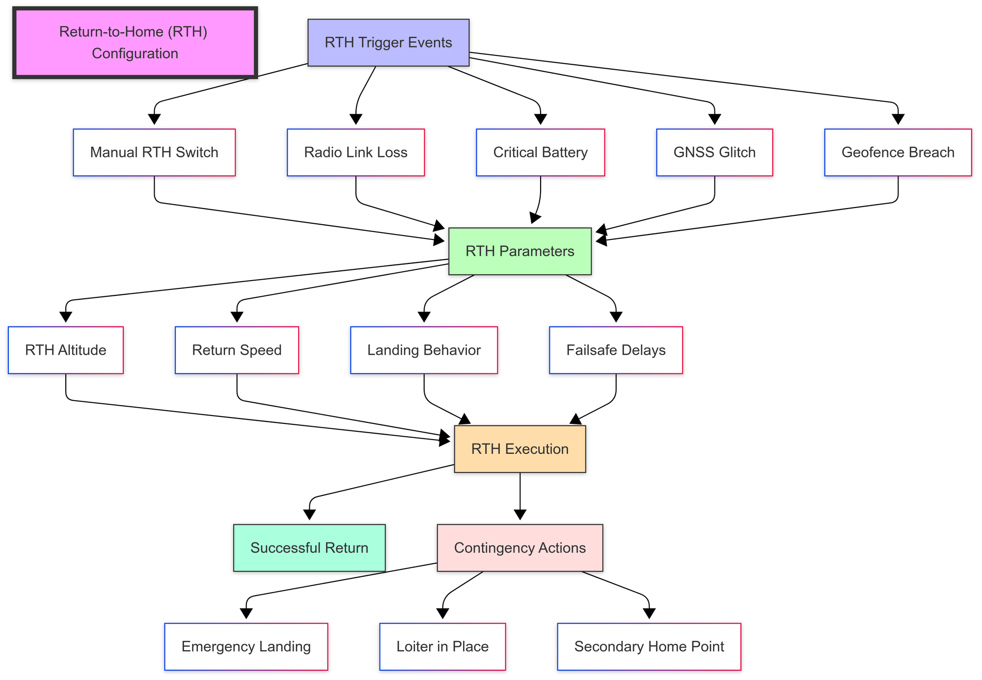
| RTH Parameter | Recommended Setting | Explanation | Common Mistakes |
|---|---|---|---|
| RTH Altitude | 50-100m (adjustable based on terrain) | Must clear all obstacles between aircraft and home point | Setting too low for terrain, Not accounting for trees/buildings |
| Return Speed | 60-70% of maximum | Balances efficiency with timely return | Too fast (battery inefficient) or too slow (excessive time at distance) |
| Failsafe Delay | 1.0-1.5 seconds for signal loss | Prevents false triggers while catching real failures quickly | Too short (false triggers) or too long (excessive drift before return) |
| Battery Threshold | 3.7-3.8V per cell (LiPo), Higher for Li-ion | Ensures sufficient power for return journey | Setting too low, Not accounting for voltage sag under load |
| Home Point | Verified with 14+ satellites | Accurate home position is critical for return | Not waiting for proper satellite lock, Not verifying position |
I configure my long-range builds with three layers of RTH triggering:
- Manual RTH switch for pilot-initiated return
- Radio link loss RTH after a 1.5-second delay
- Critical battery RTH at 3.7V per cell (adjusted based on battery type)
For maximum reliability, I always test RTH functionality at close range before every long-range mission, verifying that:
- The aircraft climbs to the correct RTH altitude
- It returns directly to the home point
- The landing behavior functions as expected
- All failsafe triggers work properly
Airframe Considerations
Not all drone frames are suitable for long-range operations:
Ideal Characteristics for Long-Range Frames
- Efficiency-focused design: Clean aerodynamics, reduced weight
- 7-inch props or larger: Better efficiency than smaller props
- Adequate component space: Room for larger batteries and systems
- Streamlined profile: Reduced drag for better range
- Durable construction: Reliability in various conditions
- GPS/antenna mounting options: Clear view of the sky for navigation systems
| Frame Type | Pros for Long Range | Cons for Long Range | Best Use Case | Example Models |
|---|---|---|---|---|
| 7" Stretched X | Excellent forward flight efficiency, Good balance of agility and stability, Familiar handling | Limited component space compared to H frames, Typically heavier than true X | All-around long-range with moderate payload | iFlight XL7, TBS Source One 7", Diatone Roma F7 |
| 7" H Frame | Maximum component space, Better battery placement options, Often more streamlined | Less agile than X configurations, Can be heavier | Heavy payload long-range, Complex system integration | GEPRC Mark4 HD7, iFlight Chimera7, FlyWoo Explorer LR |
| 7" True X | Lightest option, Most agile, Balanced handling | Less efficient in forward flight, Often less component space | Long-range freestyle, Technical flying at distance | AOS 7, iFlight Nazgul Evoque F7 |
| 8"+ Frames | Maximum efficiency, Largest payload capacity, Best flight time | Heaviest option, Least agile, Requires more space to transport | Maximum range missions, Professional aerial photography | BQE Endurance 8", iFlight XL8, GEPRC Crocodile 8" |
| Low-Profile Designs | Reduced drag, Often lighter, Better penetration in wind | Limited component space, Can be harder to build | Speed-focused long-range, Windy conditions | HGLRC Wind8, iFlight Chimera8 HD, TBS Source One HD |
Popular long-range frame styles include:
- Stretched X configurations: Better forward flight efficiency
- H-frames: Room for components and batteries
- Hybrid X/H designs: Balance of efficiency and component space
- Low-profile designs: Reduced frontal area and drag
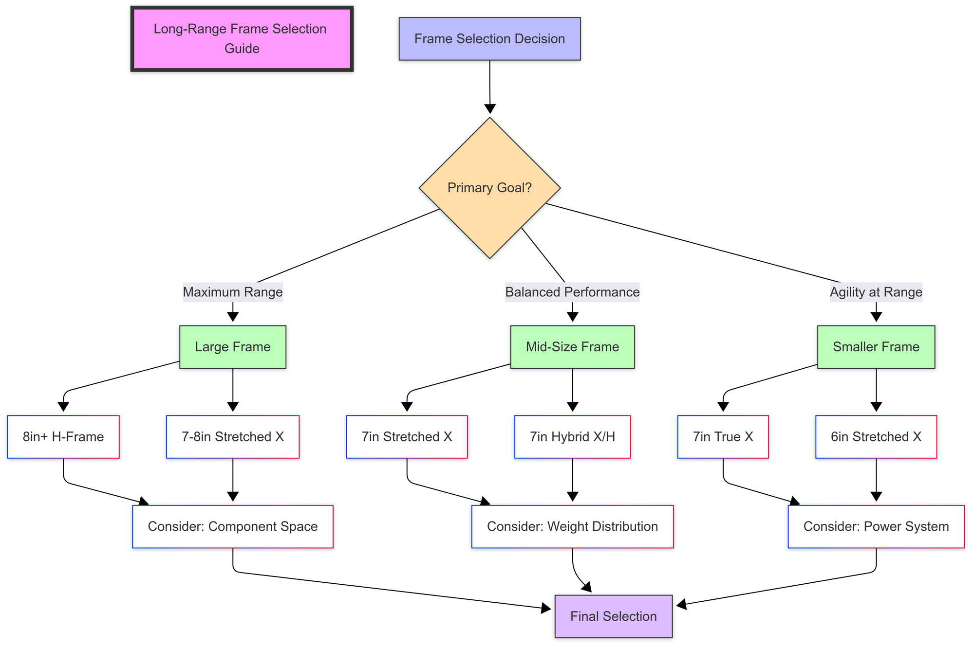
After trying numerous frames, I've found that a 7-inch stretched X or H configuration offers the best balance of efficiency, stability, and component capacity for serious long-range missions.
For more information on frame selection, see:
Drone Frames: Sizes, Materials, and Selection
Battery and Power System Optimization
Battery selection and power system efficiency are critical for maximizing range:
Battery Chemistry Comparison for Long Range
| Battery Type | Energy Density | Weight | Discharge Rate | Best Use Case |
|---|---|---|---|---|
| LiPo | Moderate | Moderate | High | Balanced performance |
| Li-ion | High | Light | Low-Moderate | Maximum range, lighter weight |
| LiHV | Moderate-High | Moderate | High | Extended performance with power demands |
| Li-ion/LiPo Hybrid | High | Moderate | Moderate | Optimized long-range with moderate power |
For maximum range, Li-ion batteries offer significantly better energy density, though with reduced current handling capability. This makes them ideal for efficient cruising but less suitable for aggressive flying.
Key battery considerations:
- Capacity vs. Weight: Larger isn't always better if the weight penalty reduces efficiency
- Discharge Rating: Match to your power system requirements
- Cell Configuration: Higher cell counts can be more efficient at lower throttle
- Parallel Configurations: Consider parallel smaller packs for better weight distribution
- Temperature Management: Monitor battery temperature during long flights
My preferred setup for maximum range is a 6S Li-ion pack using 21700 cells, which offers approximately 60-70% more flight time than an equivalent capacity LiPo while maintaining adequate power delivery for efficient cruising.
For more information on battery selection, see:
Overview of Drone Battery Types and Chemistry
Flight Controller and Software
The flight controller and its firmware are the brains of your long-range system:
Flight Controller Features for Long Range
Essential features include:
- GNSS support: Multiple constellation compatibility
- Barometer: Altitude hold and monitoring
- Compass support: Accurate heading information
- Current/voltage monitoring: Real-time power system data
- Blackbox logging: For analyzing and improving performance
- Telemetry support: Bidirectional data communication
- Robust processor: F7 or H7 for complex operations
Firmware Options
Popular firmware choices for long-range operations:
- INAV: Specifically designed for navigation and long-range
- Excellent GPS modes and RTH functionality
- Strong fixed-wing support
- Active development community
- Ardupilot: Highly capable for advanced missions
- Comprehensive mission planning
- Excellent support for various sensors
- More complex setup process
- Betaflight: With GPS rescue functionality
- Excellent flight performance
- Limited navigation capabilities
- Better for shorter-range missions
For serious long-range flying, I recommend iNav for its balance of user-friendliness and navigation capabilities, or Ardupilot for complex mission planning requirements.
For more information on flight controllers, see:
Drone Flight Controllers: Principles and Operation
Building a Long-Range System
Creating a reliable long-range system requires careful component selection and integration.
Component Selection Checklist
Use this checklist when building a long-range system:
- Frame: 7" or larger, efficiency-focused design
- Motors: Lower KV (1300-1700KV for 6S), efficiency-focused
- Props: Higher pitch, efficiency-focused designs
- Flight Controller: F7/H7 with barometer and robust GNSS support
- ESCs: 40A or higher with good thermal management
- Control Link: Long-range system (ExpressLRS/Crossfire) with diversity
- Video System: Primary and backup systems with directional capability
- GNSS Module: High-quality module with multi-constellation support
- Batteries: Li-ion for maximum range or LiPo for balanced performance
- Antennas: Directional options for both control and video
- Power Management: Filtered, redundant power where possible
System Integration Best Practices
Proper integration is as important as component selection:
| Integration Aspect | Common Mistakes | Best Practices | Impact on Range |
|---|---|---|---|
| Interference Management | Placing VTX near control receiver, Unshielded wires | Physical separation of RF components, Shielded signal wires, Filtered power | 20-30% improvement in control link reliability |
| Antenna Placement | GNSS antenna under carbon fiber, Antennas touching frame, Poor polarization | GNSS antenna on top with clear view, Control antennas away from conductive materials, Proper polarization alignment | 30-50% improvement in signal quality |
| Power Distribution | Unfiltered power to sensitive components, Single power path | Filtered power for FC and receivers, Redundant power paths, Voltage monitoring | Reduced noise and more reliable operation |
| Weight & Balance | Excessive weight, Poor CG, Unnecessary components | Optimized component selection, Balanced CG for forward flight, Minimalist approach | 10-20% improvement in flight efficiency |
I've found that careful attention to system integration can double the effective range compared to haphazardly assembled components, even when using identical parts.
Example Long-Range Build
Here's a proven component list for a capable long-range build:
- Frame: 7" iFlight XL7 V5 or TBS Source One V5
- Motors: 2306-1750KV or 2507-1500KV
- Props: 7x4.5 or 7x5 efficiency-focused
- Flight Controller: Matek H743-WING with iNav
- ESCs: 45A 4-in-1 with BlHeli_32
- Control Link: ExpressLRS 900MHz with diversity receiver
- Video System: DJI O3 Air Unit with analog backup
- GNSS: Matek M10Q-5883 multi-constellation module
- Batteries: 6S 5000-6000mAh Li-ion pack
- Antennas: Patch/directional for ground, omnidirectional for aircraft
This setup has consistently delivered 10km+ range with reliable return capability while maintaining good flight characteristics.
Flight Planning and Preparation
Proper planning is essential for safe and successful long-range operations.
Pre-Flight Planning Process
Follow this systematic approach to flight planning:
- Route Planning
- Study satellite imagery of the area
- Identify potential hazards and obstacles
- Plan primary and alternate routes
- Establish emergency landing zones
- Check elevation profiles for terrain clearance
- Regulatory Compliance
- Verify airspace restrictions
- Obtain necessary permissions
- Plan observer positions if using EVLOS approach
- Notify relevant authorities if required
- Check for temporary flight restrictions
- Weather Assessment
- Check wind conditions at various altitudes
- Verify visibility and cloud cover
- Consider sun position relative to flight path
- Monitor precipitation forecasts
- Check for thermal conditions in hot weather
- Communication Planning
- Establish observer communication protocols
- Ensure reliable communication methods
- Define standard terminology and procedures
- Plan for communication failures
- Brief all team members on emergency procedures
I use a combination of Windy, Meteoswiss, UAV Forecast, and custom checklists to ensure thorough flight planning for every long-range mission.
Mission Planning Software
Several software options can assist with flight planning:
- QGroundControl: Comprehensive mission planning for Ardupilot/PX4
- Mission Planner: Detailed planning for Ardupilot systems
- iNav Configurator: Basic planning for iNav-based systems
- Litchi: User-friendly planning for DJI platforms
- Google Earth Pro: Excellent for route visualization and elevation analysis
For complex missions, I typically plan in QGroundControl or Mission Planner, then export waypoints to my flight controller.
Pre-Flight Checklist
This comprehensive checklist covers essential pre-flight verification:
System Checks
- [ ] All firmware updated to latest stable versions
- [ ] Battery charged and balanced (storage charge if not flying immediately)
- [ ] All connections secure and checked
- [ ] Props inspected and properly tightened
- [ ] Control surfaces moving in correct directions
- [ ] Failsafes tested and verified
- [ ] RTH function tested recently
- [ ] GNSS lock with 14+ satellites across multiple constellations
- [ ] Home point set and verified
- [ ] Compass calibrated and verified
- [ ] Telemetry functioning and displaying correct data
- [ ] Video transmission clear and stable
- [ ] Control link RSSI strong and stable
- [ ] Memory card formatted and installed (if recording onboard)
Environmental Checks
- [ ] Weather conditions within acceptable parameters
- [ ] Wind speed and direction checked at flight altitude
- [ ] No approaching weather systems
- [ ] Visibility sufficient for observers
- [ ] Sun position noted to avoid flying directly into sun
- [ ] Launch area clear and stable
- [ ] Recovery zones identified
- [ ] No unexpected obstacles or hazards
- [ ] No manned aircraft in vicinity
- [ ] No people or vehicles in immediate area
Operational Checks
- [ ] Flight plan reviewed and loaded
- [ ] Observers in position and communication tested
- [ ] Authorities notified if required
- [ ] Emergency procedures reviewed with team
- [ ] Battery capacity sufficient with 30% reserve
- [ ] Return route verified clear of obstacles
- [ ] Altitude plan accounts for terrain and obstacles
- [ ] Communication devices charged and functioning
- [ ] Backup equipment ready if applicable
- [ ] Time constraints considered (daylight, battery life, etc.)
I laminate this checklist and physically check off each item before every long-range flight. This discipline has prevented numerous potential issues over the years.
Long-Range Flying Techniques
Successful long-range flying requires specific techniques that differ from typical FPV flying.
Efficient Flight Techniques
Maximizing range requires efficient flying:
- Cruise Throttle Management
- Find the "sweet spot" throttle position (typically 30-40%)
- Maintain consistent altitude to avoid unnecessary climbing
- Use gentle turns rather than aggressive maneuvers
- Avoid rapid throttle changes
- Wind Management
- Plan routes considering wind direction
- Fly into the wind on outbound leg when possible
- Use higher altitude to find favorable wind conditions
- Calculate ground speed vs. air speed for range planning
- Altitude Optimization
- Higher altitude generally improves signal propagation
- Balance altitude with battery efficiency
- Consider terrain and obstacles
- Use altitude strategically for wind advantage
- Battery Management
- Monitor voltage under load rather than percentage
- Understand voltage sag characteristics of your batteries
- Consider temperature effects on performance
- Plan conservative turnaround points (60% battery remaining)
Through careful testing, I've found that my 7" long-range build achieves maximum efficiency at 35% throttle, giving approximately 25km total range on a 6S 6000mAh Li-ion pack in calm conditions.
Navigation Techniques
Maintaining situational awareness is critical:
- Visual References
- Identify and use distinctive landmarks
- Note sun position for orientation
- Use roads, rivers, and other linear features as guides
- Create mental map of the terrain
- Telemetry Utilization
- Monitor distance and direction to home
- Track altitude consistently
- Use artificial horizon for orientation
- Verify GNSS status regularly
- Orientation Management
- Practice flying with various orientations
- Use heading hold modes when appropriate
- Understand control reversal at distance
- Maintain awareness of aircraft orientation relative to home
- Emergency Procedures
- Know when to trigger RTH manually
- Understand when to take over from automated systems
- Practice recovery from disorientation
- Develop protocols for video or control link degradation
I always maintain a "mental breadcrumb trail" of my route, noting distinctive features that can guide me home even if navigation systems fail.
Communication Protocols
Clear communication is essential when working with observers:
- Standard Terminology
- Use clear, consistent terms
- Confirm understanding of critical information
- Develop shorthand for common situations
- Avoid ambiguous directions
- Observer Coordination
- Position observers strategically
- Establish clear handoff procedures between observers
- Ensure all observers understand aircraft capabilities
- Practice communication before critical flights
- Emergency Communication
- Develop clear protocols for various scenarios
- Establish priority communication rules
- Ensure all team members understand emergency procedures
- Practice emergency scenarios
A simple but effective protocol I use with observers includes standard calls like "Visual confirmed" (observer has visual contact), "Transition request" (preparing to hand off to next observer), and "Command accepted" (confirming receipt of instruction).
Risk Management and Emergency Procedures
Long-range flying involves inherent risks that must be systematically managed.
Risk Assessment Framework
Use this structured approach to assess and mitigate risks:
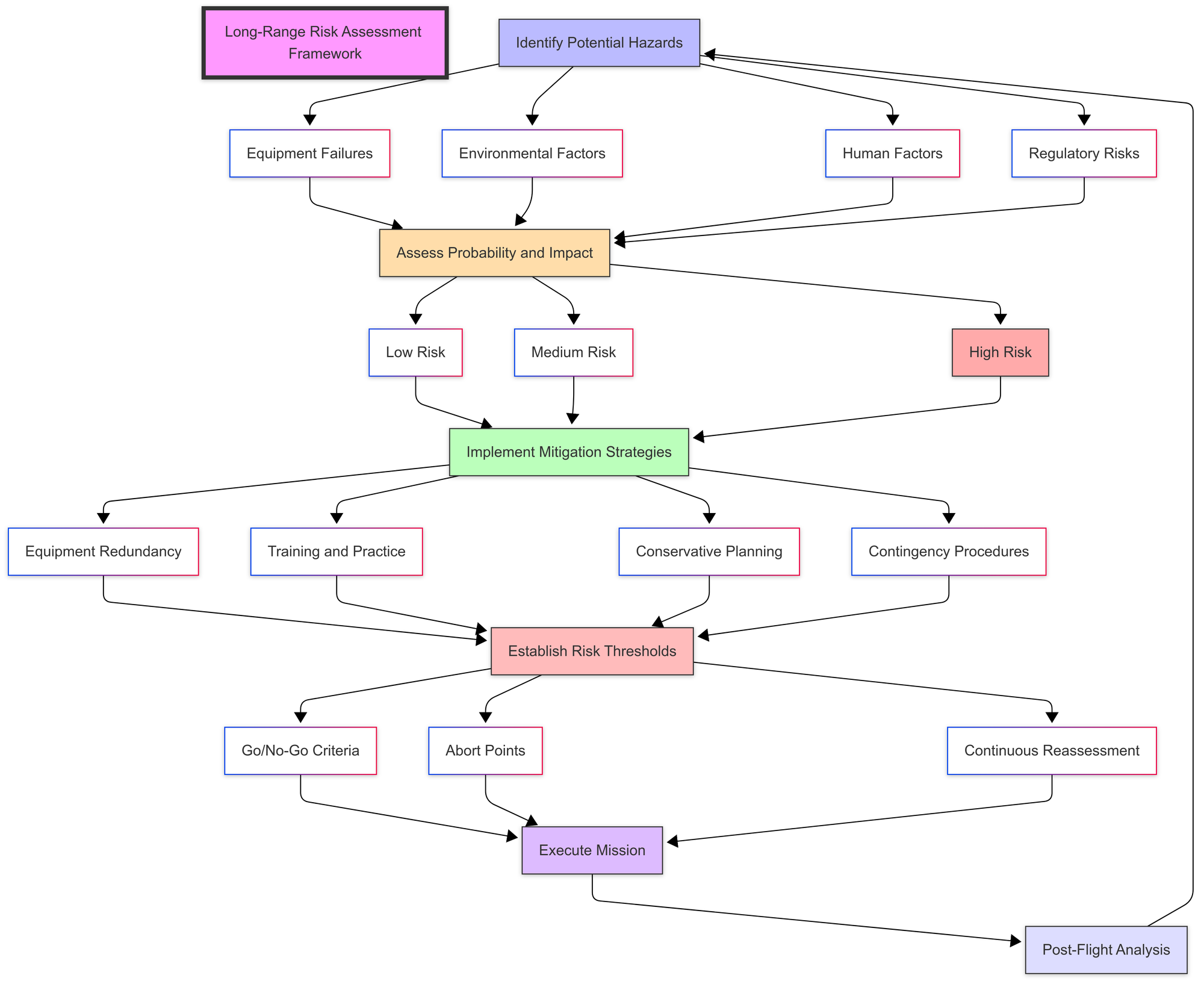
| Risk Category | Examples | Mitigation Strategies | Go/No-Go Criteria |
|---|---|---|---|
| Equipment Failures | Control link loss, Video system failure, Battery failure, GPS loss | Redundant systems, Pre-flight testing, Conservative range limits | No flight with untested equipment, Minimum 14 satellite lock, Full failsafe testing |
| Environmental Factors | High winds, Poor visibility, Precipitation, Terrain obstacles | Weather forecasting, Route planning, Altitude management | No flight in winds >25km/h, No flight in precipitation, No flight with <3km visibility |
| Human Factors | Pilot fatigue, Observer error, Communication breakdown | Team training, Clear protocols, Rest requirements | No flight when fatigued, No flight without briefed observers, No flight without comms check |
| Regulatory Risks | Airspace violations, Permit requirements, Observer compliance | Pre-flight research, Documentation, Authority notification | No flight in restricted airspace, No flight without required permissions, No flight without proper documentation |
I document a formal risk assessment for complex long-range missions, which has proven invaluable for identifying non-obvious risks and appropriate mitigations.
Common Failure Modes and Responses
Prepare for these common issues:
Control Link Failure
- Prevention: Diversity systems, range testing, antenna positioning
- Response: Allow RTH to engage, avoid manual override unless necessary
- Recovery: Monitor telemetry for proper RTH execution
Video Link Failure
- Prevention: Dual systems, directional antennas, power management
- Response: Maintain straight flight, switch to backup video system
- Recovery: Use telemetry data for orientation, consider manual RTH
GNSS Failure
- Prevention: Multi-constellation systems, interference mitigation
- Response: Switch to attitude mode, maintain orientation, begin return
- Recovery: Use visual references and telemetry for navigation
Battery Failure
- Prevention: Conservative planning, temperature management
- Response: Immediate RTH, reduce power consumption
- Recovery: Identify emergency landing zones if necessary
Orientation Loss
- Prevention: Maintain visual references, use heading hold modes
- Response: Level aircraft, check telemetry for orientation
- Recovery: Use RTH if disorientation persists
For each failure mode, I practice the response procedures regularly at safe distances before attempting long-range flights.
Emergency Landing Procedures
When RTH isn't possible:
- Site Selection Criteria
- Open areas free of people and structures
- Accessible for recovery
- Minimal hazards (water, power lines, etc.)
- Visible in FPV feed
- Controlled Descent Technique
- Maintain forward momentum
- Reduce altitude gradually
- Approach into wind when possible
- Cut power before ground contact
- Recovery Planning
- Mark landing location via telemetry
- Use satellite imagery for navigation
- Consider property access issues
- Bring appropriate recovery tools
I always identify at least three potential emergency landing zones along my planned route before takeoff.
Advanced Long-Range Capabilities
For experienced pilots, these advanced capabilities can enhance long-range operations.
Waypoint Missions
Automated waypoint missions offer precision and consistency:
- Mission Planning Software
- QGroundControl
- Mission Planner
- iNav Configurator
- DJI/Litchi for DJI platforms
- Waypoint Types
- Position waypoints (lat/long/alt)
- Action waypoints (camera triggers, etc.)
- Conditional waypoints (based on sensors/time)
- Return waypoints
- Mission Parameters
- Speed between waypoints
- Loiter time at waypoints
- Altitude changes
- Heading requirements
- Safety Considerations
- Failsafe integration
- Battery monitoring
- Geofencing
- Manual override capability
I use waypoint missions for complex routes or when precise positioning is required, but always maintain manual control capability and monitor the mission actively.
Terrain Following
Advanced systems can maintain consistent height above terrain:
- Implementation Methods
- Radar/lidar altimeters
- Barometric pressure with terrain database
- Pre-programmed altitude changes based on maps
- Configuration Parameters
- Minimum safe height above terrain
- Look-ahead distance
- Response rate to terrain changes
- Maximum climb/descent rates
- Limitations
- Sensor accuracy and reliability
- Terrain database resolution
- Processing requirements
- Safety margins needed
Terrain following requires careful testing and conservative safety margins, but can enable flights in mountainous areas that would otherwise be extremely challenging.
Long-Range FPV Disciplines
Specialized approaches to long-range flying:
Mountain Surfing
- Following terrain contours at close range
- Requires excellent depth perception and reaction time
- Typically uses higher-performance builds
- Demands intimate knowledge of the area
Cross-Country Expeditions
- Multi-stage flights with battery changes
- Requires ground support team
- Focuses on maximum distance achievement
- Often uses fixed-wing or VTOL platforms
Long-Range Freestyle
- Combining distance with acrobatic maneuvers
- Requires higher-power systems than pure long-range
- Balances efficiency with performance
- Often uses 6" builds for balance of range and agility
Aerial Photography Missions
- Capturing specific subjects at distance
- Emphasizes stability and camera quality
- Often uses larger, more stable platforms
- May incorporate gimbal systems
I've found mountain surfing to be particularly rewarding, though it requires significant practice at closer ranges before attempting at distance.
Equipment and Accessories
Specialized equipment enhances long-range capabilities.
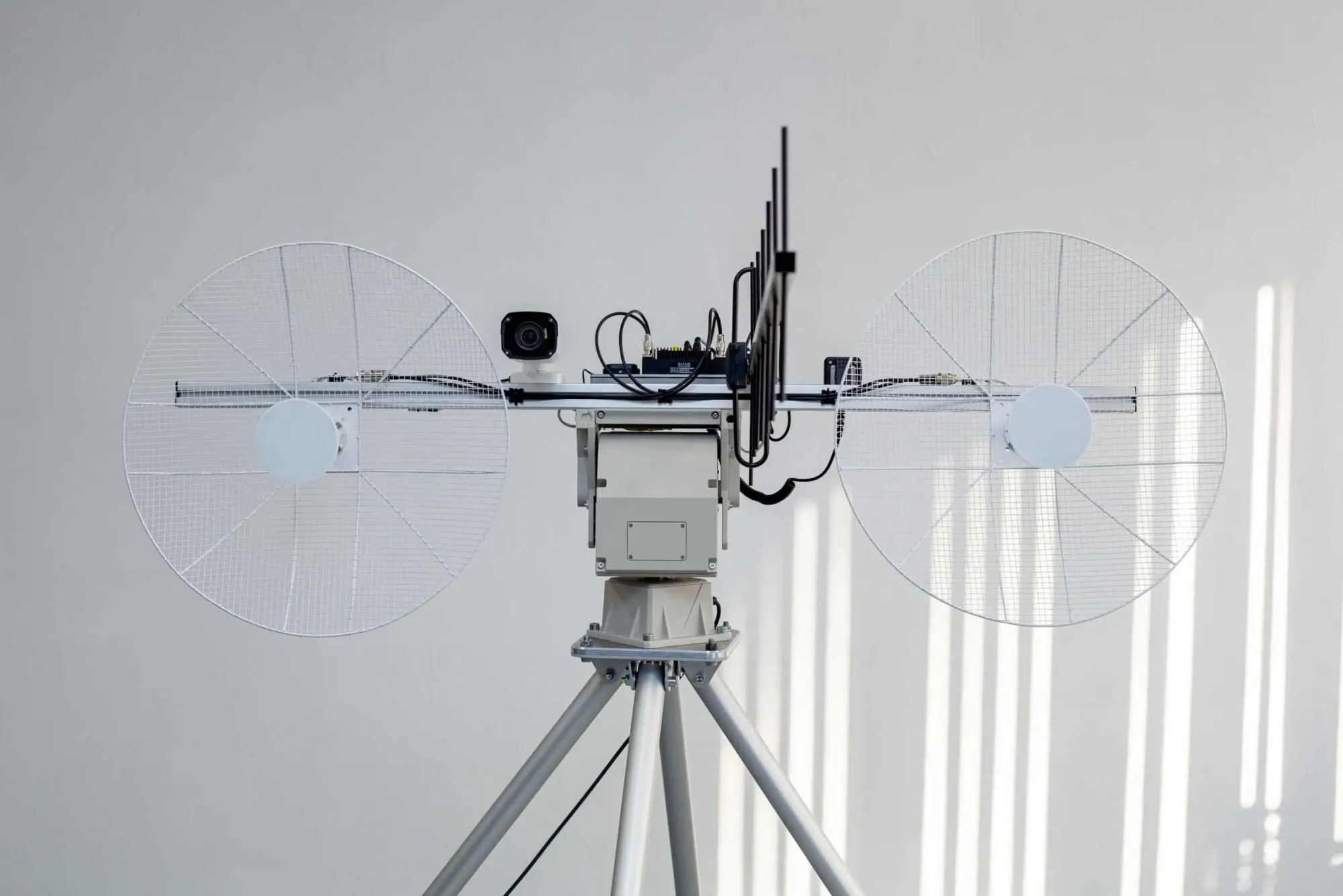
Ground Station Setup
A proper ground station significantly improves the long-range experience:
- Antenna Systems
- Directional antennas (patch, helical, yagi)
- Antenna trackers (manual or automated)
- Diversity receivers
- Amplifiers (where legally permitted)
- Monitoring Equipment
- Secondary screens for telemetry
- Spectrum analyzers
- Battery voltage monitors
- Signal strength indicators
- Support Equipment
- Weather monitoring tools
- Communication systems for observers
- Backup power supplies
- Sunshades for screens
- Comfort Considerations
- Seating for extended sessions
- Sun/weather protection
- Hydration and sustenance
- Appropriate clothing
My portable ground station includes a folding chair, small table, diversity receiver with patch and omni antennas, telemetry display, and communication headsets for observers. This setup packs into a single backpack but provides all the essentials for effective long-range operations.
Antenna Trackers
Antenna trackers can dramatically improve signal quality:
- Manual Trackers
- Require operator to physically aim the antenna
- Simple and reliable
- Lower cost
- Good for beginners
- Automated Trackers
- Use telemetry data to automatically aim antennas
- Free up operator attention for flying
- More complex setup
- Higher initial investment
- DIY Options
- Arduino-based trackers
- 3D printed mechanisms
- Telemetry-driven positioning
- Cost-effective for experienced builders
I started with a simple manual tracker using a tripod and directional patch antenna, which improved my effective range by approximately 40% compared to a static setup. For serious long-range missions, I now use an automated tracker that maintains perfect antenna alignment throughout the flight.
For more information on antennas, see:
Portable Power Solutions
Extended sessions require reliable power:
- Battery Options
- LiPo power stations
- Solar chargers
- Power banks with appropriate outputs
- Automotive power inverters
- Power Management
- Prioritize critical systems
- Monitor consumption
- Bring backup options
- Consider runtime requirements
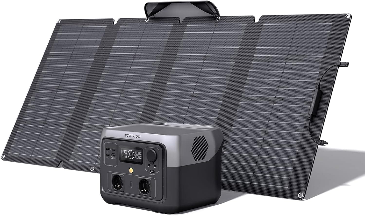
For day-long sessions, I use a combination of high-capacity LiPo batteries and a foldable solar panel, which provides sufficient power for my ground station while remaining portable enough for remote locations.
Legal and Ethical Best Practices
Responsible long-range flying extends beyond technical considerations.
Documentation and Permissions
Maintain proper documentation:
- Required Documentation
- Drone registration information
- Pilot certification/license
- Insurance documentation
- Flight logs and maintenance records
- Risk assessments and flight plans
- Permission Procedures
- Landowner permission for takeoff/landing
- Airspace authorization where required
- Observer agreements and briefings
- Notification to relevant authorities
- Special permissions for protected areas
I keep a dedicated folder with all relevant documentation, permissions, and contact information for each flying location. This has proven invaluable when questions arise from authorities or other stakeholders.
Environmental Considerations
Minimize impact on nature and wildlife:
- Wildlife Protection
- Research sensitive species in the area
- Maintain appropriate distance from wildlife
- Avoid nesting areas and breeding seasons
- Monitor animal reactions and adjust accordingly
- Noise Management
- Use efficient props to reduce noise
- Maintain higher altitudes over sensitive areas
- Consider time of day for operations
- Limit flight time in any one area
- Physical Impact
- Leave no trace at launch/landing sites
- Have recovery plans that minimize environmental impact
- Consider alternatives to landing in sensitive areas
- Avoid disturbing soil, plants, or habitats
I once aborted a planned mountain flight after discovering it would pass near a protected eagle nesting site. While disappointing, respecting wildlife and protected areas is non-negotiable for responsible pilots.
Community Relations
Maintain positive relationships with the broader community:
- Public Perception Management
- Be prepared to explain your activities
- Demonstrate safety measures and precautions
- Share beautiful rather than controversial footage
- Act as an ambassador for the hobby
- Collaboration Opportunities
- Work with local clubs and organizations
- Participate in community education
- Assist with search and rescue or conservation efforts
- Share knowledge with other pilots
- Conflict Avoidance
- Fly away from populated areas
- Respect privacy concerns
- Address questions or concerns respectfully
- Be willing to modify plans based on feedback
Building positive relationships with landowners, local authorities, and communities has opened up amazing flying opportunities that would otherwise be inaccessible. Taking time to explain your safety protocols and share the beauty of aerial photography can transform skeptics into supporters.
Pro Tips for Long-Range Success
After years of pushing the boundaries of long-range flying, I've developed these advanced insights:
Weather Optimization
Understanding weather patterns is crucial:
- Thermal Activity
- Morning and evening typically offer calmer conditions
- Visible cumulus clouds indicate active thermals
- Dark ground features create stronger thermals
- Consistent wind direction suggests organized thermal patterns
- Wind Layers
- Wind often changes direction and speed at different altitudes
- Use weather forecasting tools that show wind at various heights
- Experiment with altitude to find favorable wind conditions
- Consider wind gradient effects near terrain
- Pressure Systems
- High-pressure systems typically offer better flying conditions
- Rising barometric pressure often indicates improving conditions
- Falling pressure may signal approaching weather systems
- Stable pressure suggests consistent conditions
I once gained an additional 5km of range by climbing to 250m altitude to catch a tailwind on the return journey, effectively doubling my effective battery capacity through smart use of weather conditions.
Range Optimization Techniques
Maximize your effective range:
- Aerodynamic Improvements
- Clean builds with minimal protrusions
- Properly tensioned battery straps
- Streamlined antenna mounting
- Minimal exposed wiring
- Weight Reduction Strategies
- Lighter battery options (Li-ion vs LiPo)
- Minimal hardware
- Carbon fiber parts where appropriate
- Evaluate necessity of each component
- Power System Efficiency
- Motor and prop matching for cruise efficiency
- ESC settings optimization
- Minimal idle throttle
- Battery load optimization
- Signal Optimization
- Frequency coordination to avoid interference
- Antenna polarization matching
- Ground station elevation
- Minimal obstructions in signal path
Through methodical testing and optimization, I've increased the range of my primary long-range build by over 40% without changing any major components—just through careful tuning and optimization of existing systems.
Mental Preparation
The psychological aspect of long-range flying is often overlooked:
- Stress Management
- Practice progressive distance increases
- Develop confidence in your systems
- Prepare for various scenarios mentally
- Know when to abort based on comfort level
- Focus Techniques
- Eliminate distractions during critical flights
- Maintain situational awareness
- Develop scanning patterns for instruments
- Practice information prioritization
- Decision Making
- Establish go/no-go criteria before flight
- Define abort triggers during mission
- Remove emotion from safety decisions
- Trust your preparation and systems
I've found that mental preparation is as important as technical preparation. The ability to remain calm and make rational decisions when your aircraft is kilometers away is a skill that must be developed through progressive practice.
FAQ: Common Questions About Long-Range Flying
Is long-range flying legal?
The legality depends entirely on your location and how you operate. Most countries prohibit beyond visual line of sight (BVLOS) operations without special authorization. However, using visual observers to maintain EVLOS operations can be legal in many jurisdictions with proper protocols. Always research the specific regulations for your location, consider obtaining appropriate authorizations, and never fly in restricted airspace. The most responsible approach is to contact your local aviation authority directly if you're uncertain about the legality of your planned operations.
For more detailed information on country-specific regulations, see these comprehensive guides:
What's the maximum range possible with current technology?
With optimal conditions and equipment, hobby-grade systems can achieve 30+ kilometers using 900MHz control systems, high-quality video links, and efficient aircraft. Commercial systems can extend significantly further. However, the practical limit for responsible operations is determined by your ability to maintain legal compliance, ensure safety, and manage risks—not by the technical limitations of your equipment. Focus on building reliable systems with appropriate redundancy rather than maximum theoretical range.
Do I need special licenses for long-range flying?
This varies by country. In many jurisdictions, standard drone registration and basic pilot certification are sufficient for VLOS operations, while BVLOS operations may require additional licensing or waivers. Some countries require radio operator licenses for certain transmitters, particularly higher-power or non-standard frequency systems. Research the specific requirements for your location and intended operations. When in doubt, contact your national aviation authority for guidance.
What's the best radio system for long-range?
Currently, ExpressLRS and TBS Crossfire are the leading control link systems for long-range operations. ExpressLRS has gained significant popularity due to its open-source nature, exceptional performance, and active development community. For maximum range, 900MHz systems (or 433MHz where legal) offer significant advantages over 2.4GHz systems due to better obstacle penetration and signal propagation characteristics. The ideal system depends on your specific requirements, budget, and the regulatory environment in your location.
For more details on control systems, see our comprehensive guide:
How do I prevent flyaways?
Preventing flyaways requires multiple layers of protection:
- Properly configured and tested failsafes on both the receiver and flight controller
- Conservative RTH trigger points for battery voltage and signal loss
- Regular compass calibration and verification
- Adequate GPS satellite lock before takeoff
- Thorough pre-flight testing of all systems
- Conservative flight planning with adequate margins
- Regular maintenance and inspection of all components
Never attempt long-range flights without thoroughly testing your failsafe and RTH systems at close range first.
How can I extend my video range?
To maximize video range:
- Use directional antennas on the ground station (patch, helical, or yagi)
- Implement an antenna tracker (manual or automatic)
- Position ground station antennas with clear line of sight
- Use diversity receivers with multiple antenna types
- Select appropriate frequency bands for your environment
- Consider dual video systems (digital primary with analog backup)
- Optimize antenna placement on the aircraft
- Use high-quality, low-loss cables and connectors
For maximum range, many experienced pilots use a combination of digital and analog systems to leverage the clarity of digital with the graceful degradation of analog.
For more details on FPV systems, see our comprehensive guide:
What batteries are best for long-range?
For maximum range, Li-ion batteries offer the best energy density, providing significantly more flight time than equivalent LiPo batteries. Cells like the Samsung 40T, Sony VTC6, or Molicel P42A in 21700 format offer excellent performance for long-range builds. However, Li-ion batteries have lower discharge rates, making them suitable for efficient cruising but less ideal for aggressive flying. For a balance of performance and range, consider Li-ion/LiPo hybrid packs or high-quality LiHV batteries. Always ensure your power system is appropriately sized for your battery choice.
For more information on battery selection, see:
Overview of Drone Battery Types and Chemistry
How do I calculate my drone's maximum range?
Theoretical range can be estimated using:
- Battery capacity and measured current draw at cruise throttle
- Control link specifications and tested performance
- Video system range limitations
- Regulatory restrictions in your area
However, practical range is almost always limited by factors beyond simple battery capacity, including wind conditions, safety margins, legal requirements, and risk management considerations. A conservative approach is to plan for using only 60% of your battery capacity for the outbound journey, leaving 40% for return and contingencies.
What should I do if I lose video signal?
If you lose video signal:
- Maintain straight and level flight—avoid sudden movements
- Check telemetry data for orientation and position information
- Switch to backup video system if available
- Increase altitude to improve signal propagation if appropriate
- Initiate RTH manually if disorientation continues
- Monitor telemetry for successful return progress
- Be prepared to switch to attitude mode if necessary
Practice this scenario at close range to develop muscle memory for the appropriate response.
Is specialized ground station equipment necessary?
While basic long-range flights can be accomplished with standard equipment, specialized ground station components significantly improve reliability and effective range:
- Directional antennas increase signal strength dramatically
- Diversity receivers improve signal reliability
- Antenna trackers maintain optimal signal throughout the flight
- Secondary monitors for telemetry provide critical information
- Proper seating and weather protection enable better concentration
Start with basic equipment and upgrade progressively as you extend your range and experience.
Conclusion
Long-range flying represents both the pinnacle of technical achievement in the FPV hobby and its greatest responsibility. The ability to pilot an aircraft beyond visual range opens up incredible possibilities for exploration, cinematography, and pure flying enjoyment—but it also demands the highest levels of preparation, skill, and ethical consideration.
Throughout my journey from nervous 1km flights to confident multi-kilometer expeditions, I've learned that successful long-range flying is built on three equally important foundations:
- Technical Excellence: Reliable systems with appropriate redundancy, thoroughly tested and maintained
- Operational Discipline: Meticulous planning, conservative decision-making, and comprehensive risk management
- Ethical Responsibility: Legal compliance, environmental respect, and positive community relations
The most rewarding aspect of long-range flying isn't simply reaching a distance milestone—it's the comprehensive mastery of all aspects of the hobby that the pursuit demands. The skills developed through careful progression in long-range flying elevate your capabilities across all aspects of drone operations.
For those beginning their long-range journey, I encourage a methodical approach: start with thorough research, build reliable systems, test extensively at progressive distances, and always prioritize safety and responsibility over distance achievements. The true accomplishment isn't in how far you fly, but in how safely, legally, and responsibly you conduct your operations.
The future of long-range flying will likely see continued improvements in technology, potentially alongside evolving regulatory frameworks that may provide more formal paths for authorized BVLOS operations. By demonstrating responsibility and safety in our current operations, we as a community can help shape that future positively.
Whether you're exploring mountain ranges, capturing unique perspectives of landscapes, or simply enjoying the pure freedom of extended flight, long-range flying offers experiences that simply cannot be replicated in any other aspect of the hobby. With the right approach, it can be done safely, legally, and responsibly—opening up a world of possibilities for those willing to put in the preparation and practice.
References and Further Reading
- Drone Regulations Worldwide
- Swiss Drone Regulations
- Drone RC Ecosystems
- Overview of RC System Antennas
- Digital vs Analog FPV Systems
- Overview of FPV Antennas
- GNSS Technology: A Comprehensive Guide to Safe Navigation
- Drone Frames: Sizes, Materials, and Selection
- Overview of Drone Battery Types and Chemistry
External Resources
- UAV Forecast - Weather and flight condition forecasting for drone pilots
- QGroundControl - Comprehensive ground control station software
- Mission Planner - Flight planning and configuration for Ardupilot
- iNav Configurator - Configuration tool for iNav firmware
- ExpressLRS Project - Open-source long-range radio control system
- Joshua Bardwell's YouTube Channel - In-depth tutorials and information


Comments ()